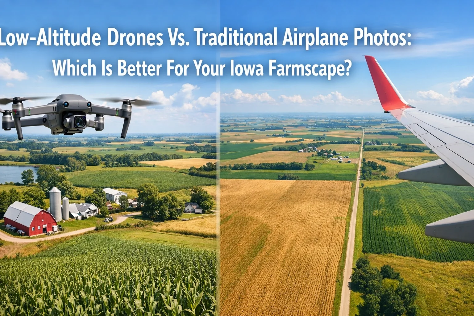
Low-Altitude Drones Vs. Traditional Airplane Photos: Which Is Better For Your Iowa Farmscape?
Low-Altitude Drones Vs. Traditional Airplane
For decades, the standard for seeing your land from above was a grainy, high-altitude photo taken from a small Cessna or Piper Cub. You probably remember the pilot who would fly over, snap a few shots, and show up at your door weeks later with a framed print. While those photos hold a certain nostalgic value, they often lack the clarity, detail, and "soul" of the land they represent.
In 2026, technology has fundamentally changed how we view the Iowa and Northern Missouri landscape. At Studio 5 Drone Productions, we’ve pioneered a new approach called Aerial Farmscapes. By utilizing low-altitude, high-resolution drone technology, we offer a level of precision that traditional airplane photography simply cannot match.
If you are looking for farm aerial photography inowa, the choice between a drone and a plane isn’t just about the equipment: it’s about the results.
The Problem with "Old-School" Airplane Fly-Bys
Traditional airplane photography is often characterized by distance. Because manned aircraft must maintain a safe altitude (usually 1,000 feet or higher), the camera is forced to look at your farm from a massive distance.
The result is often a distant, grainy, and overpriced image where your home, barns, and machinery look like tiny toys. You can see the property lines, sure, but you can’t see the texture of the corn, the glint off the pond, or the architectural details of your homestead.
Furthermore, airplane pilots have limited control over the angle. They fly a path and hope for the best. With drone services iowa, we have total control. We don't just "fly over"; we hover, adjust, and hunt for the perfect cinematic angle that showcases your farm’s unique character.
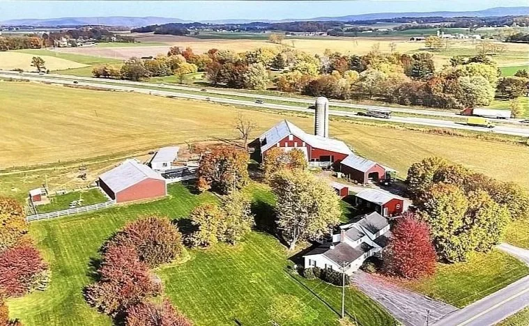
Aerial Farmscape
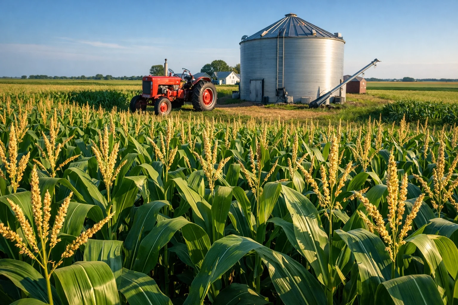
The Drone Advantage: 100x More Resolution
Research shows that drone-acquired imagery can offer over 100x the resolution of traditional plane-acquired imagery. This isn't just a marginal improvement; it is a complete generational leap.
When we deploy our DJI Air 2S quadcopter drones, we aren't just taking a picture. We are capturing data in 4K and Ultra-HD clarity. Because we fly at lower altitudes (typically under 400 feet), we can capture intimate details that airplanes miss:
The crisp lines of your freshly mowed lawn.
The specific rust patterns on a vintage tractor.
The individual tassels on your corn rows.
Vivid crop textures that tell the story of your soil health.
This level of detail is essential for farmers who want more than just a "pretty picture." It’s about capturing the legacy of the land in a way that can be passed down for generations.
Aerial Farmscapes: A Signature Studio 5 Service
At Studio 5 Drone Productions, we don't just provide "drone photos." We provide Aerial Farmscapes. This is our signature service designed specifically for the heartland.
An Aerial Farmscape is a curated, high-definition visual record of your property. We combine professional-grade photography with an artistic eye to produce images that look like they belong in a gallery. Whether it’s the way the sunrise hits your silos or the symmetry of your fields after harvest, we capture the pride of ownership that comes with being an Iowa farmer.
Our process involves finding the "Golden Hour" light and using HDR (High Dynamic Range) processing to ensure the colors of your land pop with life. You won’t find these vibrant greens and deep Iowa sunsets in a grainy airplane photo.
Technical Precision vs. Bulk Coverage
It is true that traditional airplanes can cover thousands of acres in a single day. If you need a basic map of 20,000 contiguous acres for a corporate report, a plane might be efficient. However, for the individual landowner or family farm, drones win every time.
Drones excel at field-specific management and detailed inspection. If you have a problem area in a 160-acre plot, a drone can hover directly over it, capturing multispectral data or high-res 4K video to help you identify drainage issues or pest infestations.
We provide the "direct access" that national companies and airplane pilots can't. When you hire us, you’re getting a local partner who understands the Iowa terrain and is accountable to you, not a distant corporate office. You can read more about why to choose a local provider here.
Studio 5 Drone Productions
Why Accountability Matters: FAA Certification and Veteran Values
As a Veteran-owned business, Studio 5 Drone Productions is built on a foundation of integrity and precision. We don't cut corners. Every flight we conduct is FAA Part 107 certified, meaning we follow strict safety protocols and legal requirements.
Many "hobbyist" drone pilots may offer to take photos for a few dollars, but they often lack the insurance and legal certification required for commercial work. Hiring an uncertified pilot can lead to massive fines for the landowner. Before you hire anyone, make sure to check out our guide on 5 things Iowa business owners must verify.
Our military background means we approach every "mission" with a plan. We analyze airspace charts, monitor weather patterns, and ensure that our equipment is maintained to the highest standards.
More Than Just a Photo: It’s Your Legacy
For many of our clients in Iowa and Northern Missouri, the farm isn't just a business; it’s a family heirloom. It represents decades of hard work, early mornings, and a deep connection to the earth.
When we fly an Aerial Farmscape mission, we aren't just documenting GPS coordinates. We are documenting your life's work. Our low-altitude perspective allows us to capture the "feel" of the farm: the path you walk to the barn, the shade tree where your kids play, and the vastness of the horizon.
This intimate perspective is simply impossible from a high-flying airplane. We take the time to listen to what parts of the land matter most to you, ensuring those features are the stars of the show.
Pricing and Turnaround: No Hidden Fees
One of the biggest frustrations with traditional airplane photography is the lack of transparency. Often, you don't know the price until the pilot shows up at your door with a printed photo, hoping you'll buy it on impulse.
At Studio 5 Drone Productions, we believe in straightforward, professional pricing. We offer clear packages for our farm aerial photography iowa services. Because we don't have the massive overhead of fuel, hangar fees, and aircraft maintenance that a traditional pilot has, we can offer premium 4K results at a competitive price point.
Our turnaround time is also significantly faster. You won't be waiting weeks for a lab to develop film. We deliver your high-resolution digital files: and high-quality prints if requested: quickly and efficiently.
Ready to See Your Land Like Never Before?
The era of the blurry airplane photo is over. If you want to showcase your property with the clarity and cinematic beauty it deserves, it’s time to look at the drone alternative.
Whether you are looking to create a piece of art for your living room, document your progress for a farm-to-table business, or simply want a high-res record of your land's boundaries, Studio 5 Drone Productions is here to help.
Our Credentials at a Glance:
FAA Part 107 Certified for legal commercial operations.
Veteran-Owned and Operated with a focus on precision and reliability.
Ultra-HD 4K Video and Photography capabilities.
Specialized in Aerial Farmscapes for Iowa and Northern Missouri.
Visit our main blog page to see more examples of our work, or contact us today to schedule your flight. Let’s capture your legacy from a perspective that truly does it justice.